
By Mark A Leon
Charleston is a beautiful, historic coastal city — and one of the most climate-exposed cities in the continental United States. Over the past century the city’s waterfront and low-lying neighborhoods have already seen measurable sea-level rise and a dramatic uptick in high-tide (“sunny day” or “nuisance”) flooding. If greenhouse-gas emissions continue to push global warming upward, Charleston faces increasing frequency and severity of floods that threaten lives, infrastructure, the local economy, and irreplaceable cultural assets. This article summarizes the best available data, what it means for risk in Charleston, and practical actions the city and residents can take.
What the data shows
• The long-term tide gauge at Charleston shows a relative sea level trend of about 3.51 mm per year, roughly 0.35 m (≈1.15 ft) per century at the gauge’s location.
• Tidal flooding in Charleston has gone from occasional in past decades to near-routine: researchers and federal agencies report counts like 10–25 tidal floods per year in the 1990s, rising to dozens of events annually (e.g., 89 events in 2019). Projections from local and federal analyses foresee tens to hundreds of flood-days per year under mid-century sea-level scenarios.
⸻
Why Charleston is especially vulnerable
1. Measured sea-level rise plus land subsidence.
The tidal record at the Cooper River/Charleston gauge documents an accelerating relative sea-level rise (the combination of rising ocean and any local land movement). That baseline trend amplifies the height of ordinary tides, king tides, and storm surges — turning what used to be a rare “high water” into repeated street-flooding events.
2. Rapid increase in nuisance/tidal flooding.
NOAA, NASA and peer-reviewed researchers have documented rising nuisance flooding frequency in Charleston. One forecast for the Charleston peninsula indicates nuisance flood exposure growing substantially by mid-century (for example, dozens of flood days per year under plausible scenarios). Those floods happen without storms and can shut down downtown streets, overwhelm drains, and salt-contaminate soils and infrastructure.
3. Compound events (tides + rainfall + storms).
High tides combined with heavy rainfall, or synchronized with tropical storms and nor’easters, produce much larger impacts than any single driver alone. Recent nor’easters and tropical events have produced some of the highest recorded tide levels and widespread coastal and urban flooding in Charleston.
4. Threat to infrastructure, public health and heritage.
Rising, repeated flooding damages roads, bridges, sewer and stormwater systems, electrical substations, and water treatment plants. Floodwaters can cause sewage overflows, mold in buildings, and longer-term salt water intrusion into freshwater and soils — all with public-health and economic consequences. Historic properties and cultural landscapes that make Charleston unique are also at risk. Studies on coastal U.S. infrastructure show many critical sites (hospitals, schools, utilities) could face routine flooding by mid-century.
⸻
Numbers that matter (selected quantitative findings)
• 3.51 mm/year sea-level trend at the Charleston tide gauge (monthly mean record covering 1901–2024). That’s about 1.15 feet per 100 years if the trend persisted.
• Historic increase in tidal floods: Charleston’s tidal-flood frequency has shifted dramatically — single-digit/low-double-digit events in the 1990s versus dozens to nearly 100 reported events in recent years (e.g., 89 in 2019).
• Projected nuisance-flood days: national and regional NOAA outlooks indicate many coastal communities could see 45–85 high-tide flood days per year by 2050 under a ~1-ft sea-level rise scenario; localized forecasts for the Charleston peninsula suggest dozens of flood-days per year by mid-century.
(Each of the numbers above comes from tide-gauge records, NOAA analysis, peer-reviewed modeling, and local projections. See sources cited throughout.)
⸻
Concrete impacts already being observed
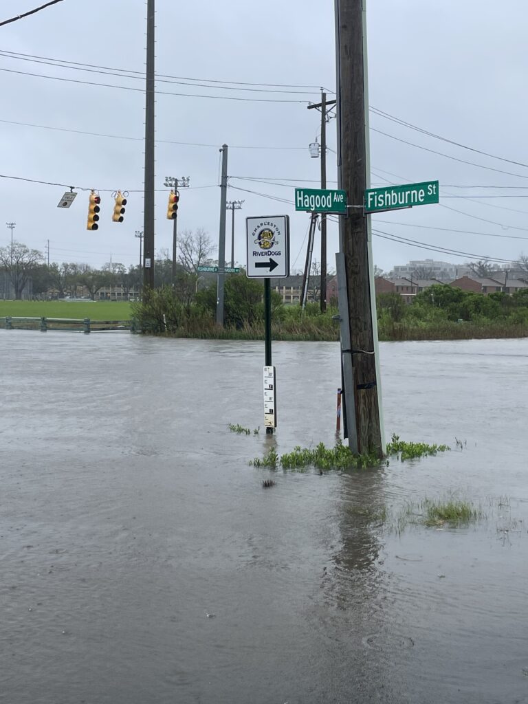
• Regular street flooding in downtown Charleston during seasonal high tides; closures of low-lying roads such as parts of Lockwood Boulevard and East Bay Street.
• Storm-enhanced tides producing record highs and acute damage during nor’easters and tropical systems (examples documented in 2023–2024 events).
• Growing municipal concern and planning: the City of Charleston has updated a 2023 Flooding & Sea Level Rise Strategy that expands investments in drainage, infrastructure elevation, and planning tools.
⸻
Why this matters for people and policy
• Economy & livelihoods: repeated flooding disrupts tourism, retail, and ports; repair costs (public and private) compound over time.
• Equity: flood impacts often fall hardest on lower-income neighborhoods and historically marginalized communities that lack resources to adapt, raise homes, or relocate. National studies show many critical public assets (schools, public housing, health facilities) will likely face recurrent flooding unless adaptation accelerates.
• Cultural heritage: Charleston’s historic district and National Historic Landmarks are at risk from chronic inundation and episodic storm damage. Preservation raises complex tradeoffs between protecting fabric in place and potential retreat strategies.

⸻
What science and local planning recommend (evidence-based actions)
City and federal guidance point to a mix of strategies — there is no single fix. Effective approaches generally include:
• Upgrade and redesign drainage and stormwater systems to accommodate higher base water levels and backflow from tidal channels. (City strategies emphasize targeted drainage projects and pump capacity upgrades.)
• Raise or harden critical infrastructure (roads, utilities, substations) and prioritize protection of hospitals, emergency routes, and wastewater plants.
• Nature-based solutions — restore and expand marshes, oyster reefs, and living shorelines that attenuate wave energy and provide ecological benefits.
• Strategic retreat and zoning reforms in places where protection is not cost-effective or causes unacceptable ecological or social harm. Thoughtful planning can reduce long-term costs and avoid locking in vulnerable investments.
• Equity-centered policy — prioritize funding and adaptation measures for disadvantaged communities to avoid worsening environmental injustice.
⸻
What residents can do (practical steps)
• Know your flood risk: check updated local maps and the Charleston Sea Level Rise Viewer or TideEye tracker for tide forecasts and inundation mapping.
• Buy appropriate flood insurance and understand coverage limits (standard homeowners’ policies usually do not cover flooding).
• Prepare an emergency plan and kit, elevate critical utilities where possible, and consider property-level flood proofing (elevating HVAC, adding check valves).
• Engage in community planning — attend local adaptation workshops and support equitable investment in resilience.
⸻
Key takeaways
1. Charleston’s tide gauge shows a multi-decadal sea-level rise trend of ~3.51 mm/yr, already contributing to more frequent tidal flooding.
2. Nuisance (high-tide) flooding has jumped from rare to routine; recent years saw tens to nearly 100 high-tide events, with projections showing many more days per year of flooding by mid-century.
3. Repeated flooding threatens infrastructure, public health, the local economy, and historic resources — and will disproportionately affect vulnerable communities without targeted equity measures.
4. Adaptation requires a portfolio of investments (drainage upgrades, nature-based defenses, targeted hardening, and strategic retreat) combined with robust planning and funding.
5. Individual preparedness (flood insurance, elevation, emergency planning) plus civic engagement will help communities manage growing risk while policymakers implement large-scale solutions.
Charleston Sea-Level Rise & Flooding – FAQ
1. How much is sea level rising in Charleston?
The Charleston tide gauge shows a long-term rise of ~3.51 mm/year — about 1.15 feet per century — and the rate is accelerating. This combines global sea-level rise with local land subsidence.
⸻
2. Why is flooding getting worse?
• Higher baseline water levels from sea-level rise.
• More intense rainstorms overwhelming storm drains.
• Compound flooding when heavy rain coincides with high tides or storms.
• Charleston’s flat, low-lying topography makes drainage slow and backflow from tides easier.
⸻
3. What is “nuisance” or “sunny day” flooding?
This is tidal flooding that happens without storms — often during king tides or seasonal high tides. In the 1990s, Charleston saw around 10–25 such days per year. Recently, that number has jumped to dozens annually (89 days in 2019).
⸻
4. What’s the forecast for mid-century?
NOAA projections suggest Charleston could experience 45–85 tidal flood days per year by 2050 under moderate scenarios — meaning water in the streets nearly twice a week.
⸻
5. What areas are most at risk?
• Downtown peninsula (East Bay St., Market area, Lockwood Blvd.)
• West Ashley marsh-adjacent neighborhoods
• Barrier islands and low-lying waterfront properties
⸻
6. What are the economic impacts?
• Tourism losses when roads and attractions close.
• Property damage from saltwater intrusion, mold, and infrastructure failures.
• Rising insurance costs and possible loss of coverage in high-risk areas.
⸻
7. How does flooding affect public health?
• Exposure to bacteria and pollutants in floodwaters.
• Mold-related respiratory issues.
• Stress and mental health impacts from repeated disruption and property loss.
⸻
8. What is the City of Charleston doing?
The 2023 Flooding & Sea Level Rise Strategy focuses on:
• Major drainage and pump system upgrades
• Raising roads and critical infrastructure
• Expanding natural buffers like marshes and oyster reefs
• Updating zoning and building codes in high-risk areas
⸻
9. What can residents do right now?
• Check your flood risk on NOAA or city maps.
• Buy flood insurance (homeowners’ policies don’t cover flooding).
• Elevate utilities like HVAC units and electrical panels.
• Install backflow preventers to stop water from coming up through drains.
• Keep an emergency plan and supplies ready.
⸻
10. Where can I track tides and flooding?
• NOAA Tide Predictions: tidesandcurrents.noaa.gov
• Charleston Sea Level Rise Viewer: scseagrant.org
• TideEye Charleston: realtime tide and flooding forecasts
Stay connected and subscribe to Charleston Daily.
It’s flooding because you have aloud to much building …stop! You have redirected the natural flow of water !!!!
Y’all are at sea level, what did you expect? Also with very low retaining walls, if it all. Policies seem designed by the companies who do restoration work for the historic district – keeps them in work and in the money.
A good French drain around the city can take care of this and wouldn’t be that expensive. Victim mentality here is very un-Charleston like.