 by
By Mark A Leon
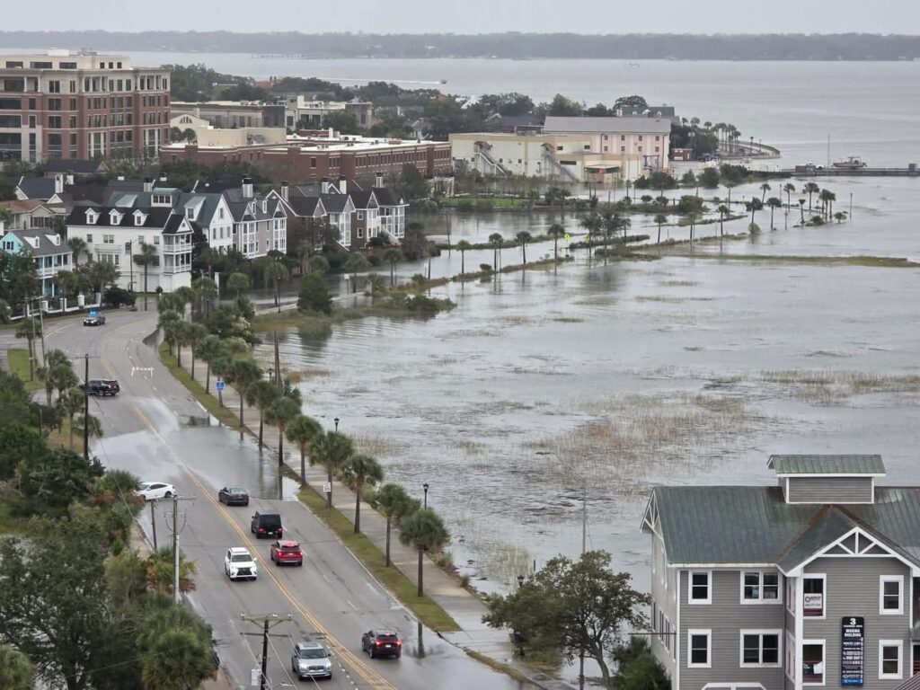
From South Lockwood Drive to the Calhoun Street merge off the James Island Connector, tidal flooding creates a daily headache for commuters. Charleston is studying solutions, but the question is how quickly those plans can translate into meaningful relief.
For people commuting from James Island into downtown Charleston, the morning drive can become a test of patience before the workday even begins.
Along the west end of the peninsula, high-tide flooding on South Lockwood Drive can disrupt traffic, force drivers to slow down or seek alternate routes, and add pressure to an already constrained corridor leading toward the Calhoun Street merge from the James Island Connector.
And when water covers a roadway that thousands of people rely on to get to work, school, medical appointments and businesses, the consequences extend well beyond a few extra minutes in traffic.
The frustrating part? It does not always have to rain for the problem to occur.
Charleston’s own flood data identifies Lockwood Drive as one of the city’s most flood-prone roads. The city’s analysis lists 144 flood-related closures on Lockwood Drive, including 87 associated primarily with high tides. That makes it a particularly clear example of how tidal flooding can interfere with daily transportation.
For commuters, the question is straightforward: Can anything be done to keep this vital route moving?
Why this stretch of road is so vulnerable
Charleston faces three overlapping flood threats: high tides, heavy rainfall and coastal storm surge. These problems can compound one another when elevated water levels prevent stormwater from draining efficiently.
During high tide, water can push into low-lying areas and restrict the ability of drainage systems to move water away from streets. When heavy rain arrives before the tide recedes, standing water can become more persistent.
The City of Charleston acknowledges that flooding is occurring more frequently and has reported approximately 13 inches of sea-level rise over the past century, with a substantial portion occurring in recent decades.
The transportation challenge is especially acute along the peninsula’s western edge, where road capacity is limited and commuters converge on a relatively small number of routes.
When flooding affects South Lockwood Drive, traffic disruptions can ripple into nearby streets and the approaches to the James Island Connector. Drivers have fewer convenient alternatives, and even a relatively localized flood can create a much larger commute problem.
Can anything be done? Charleston has several options on the table
The answer is yes, but meaningful relief will require more than clearing storm drains or waiting for the tide to go out. It will take a combination of targeted improvements and longer-term flood protection.
1. Improve drainage and install pumps
One option is to expand drainage capacity and use pump stations to move water out of vulnerable areas when high tides prevent gravity drainage.
Charleston and the U.S. Army Corps of Engineers are examining options such as larger drainage pipes, pump stations and road elevation as part of a broader tidal and inland flooding study. The goal is to identify practical projects for downtown, James Island and West Ashley.
For commuters, the key question is whether this work can identify specific drainage improvements that reduce recurring flooding along the Lockwood corridor and surrounding approach roads.
2. Build flood barriers along Lockwood Drive
There is already a larger project aimed at protecting portions of the peninsula from coastal flooding.
The Battery Extension project includes a planned flood-protection segment along Lockwood Drive between the U.S. Coast Guard and Ashley River bridges. According to the city’s 2026 project materials, the segment is approximately 7,390 linear feet, with construction planned to begin in 2028.
In September 2026, the Army Corps advanced engineering work on the Lockwood corridor, awarding a $3.31 million design contract for surveys, geotechnical investigations and other early-stage work. The overall project is intended to reduce coastal flooding and storm-surge risks.
This is significant progress, but it is important to distinguish between storm-surge protection and everyday tidal flooding. A flood barrier alone will not necessarily solve every drainage problem, especially when rainfall accumulates behind a barrier.
3. Address the bottleneck as a transportation problem, too
Flood mitigation and traffic management need to be considered together.
Even if water levels are reduced, the merge near Calhoun Street can remain congested because traffic from James Island and other approaches converges on a limited road network.
Potential measures worth evaluating include:
Targeted drainage upgrades at recurring flood points affecting commuter access.
Real-time flood alerts and detour guidance so drivers can avoid impassable streets before reaching a bottleneck.
Traffic-flow studies examining whether signal timing, merge geometry or intersection changes could reduce delays when roads remain passable.
A coordinated commuter corridor plan linking flood protection, roadway operations and emergency access.
These are recommendations for further evaluation, not a claim that each measure has already been approved or funded.
The biggest challenge: turning studies into results
Charleston is no longer simply documenting its flooding problem. The city and Army Corps are evaluating possible solutions, while major flood-protection projects move into design.
But commuters need to know what those plans will mean for their daily lives.
The city’s tidal and inland flooding study is intended to narrow potential projects and develop more specific engineering designs and cost estimates. Officials have discussed options ranging from drainage upgrades to pumps and raising roads, with construction funding dependent on the solutions selected.
That leaves several important questions for city and state officials:
Which improvements could reduce flooding on South Lockwood Drive in the near term?
Can targeted drainage or pumping work be completed before larger flood barriers are built?
How will officials ensure the Calhoun Street merge and James Island Connector approaches continue functioning during high-water events?
What is the timeline from engineering studies to construction, and which agency is responsible for each part?
Those answers matter to residents, employers, medical workers, students and businesses whose schedules are affected by recurring tidal flooding.
The bottom line
Charleston cannot control the tides, but it can invest in infrastructure designed to better manage them.
The long-term Battery Extension project could provide an important layer of coastal protection. Drainage improvements, pumps and better traffic planning may offer additional ways to reduce the impact of recurring high-water events.
The challenge is making sure these efforts work together—and that officials prioritize the specific locations where flooding repeatedly disrupts the morning commute.
For drivers traveling from James Island toward downtown, the goal is not just a more resilient Charleston decades from now. It is a dependable route to work today.
The question for Charleston is no longer whether tidal flooding is a problem. The city’s own data makes that clear. The question is how quickly the solutions can reach the streets where commuters need them most.
Stay connected and subscribe to Charleston Daily.
Photo Credit: Shea Gibson – Meteorologist
