Join Nic Butler, Ph.D., historian at the Charleston County Public Library as he discusses the the inception of the French Quarter in Charleston’s Historic District. This full synopsis and 28 minute podcasts delves into a transformative time in Charleston’s history.
Click HERE to listen to the podcast
Synopsis
In September 1973, a group of preservation activists coined the term “French Quarter” to describe a single block of urban Charleston that was slated for demolition. The site was added to the National Register of Historic Places that same month, and the new name soon became part of the local lexicon. Residents have embraced and expanded the concept of Charleston’s “French Quarter” over the past half-century, but few recall the curious circumstances of its creation. The story behind the neighborhood’s popular name is required reading for true amateurs of local history.
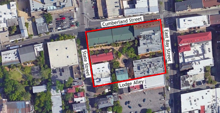
During the early days of 1973, the Atlanta-based Baier Corporation conceived a plan to redevelop a block of approximately 1.5 acres in urban Charleston, bounded by East Bay, Cumberland, and State Streets, including all of the buildings on the north side of Lodge Alley and buildings standing at the southeast end of the alley. The bulk of the structures encompassed with this block were then empty warehouses, constructed in the late nineteenth century as storage for the wholesale trade in vegetables and liquor. Wholesale commerce had dominated this part of East Bay Street during the second half of the nineteenth century and the first half of the twentieth century, but the industry moved out of the downtown area in the 1950s and 1960s to larger facilities further north up the Cooper River waterfront. On the aforementioned downtown block, the Baier Corporation planned to raze most of the vacant stores and warehouses and erect a mid-rise tower containing sixty to seventy luxury condominiums distributed across seven or eight stories measuring approximately eighty-nine feet tall (roughly the same height as the Mills House Hotel at the southwest corner of Meeting and Queen Streets). The redevelopment plan also included a row of two-story retail storefronts along East Bay and State Streets, and a twelve-foot high brick wall along Cumberland Street and parts of Lodge Alley.
https://w.soundcloud.com/player/?url=https%3A//api.soundcloud.com/tracks/1617323298&color=%23ff5500&auto_play=false&hide_related=true&show_comments=false&show_user=true&show_reposts=false&show_teaser=false
Charleston Time Machine · Episode 266: Inventing the French Quarter in 1973

The $6 million Baier project represented a major boost to the tourism economy of 1973 Charleston. On the last day of February, Alan Leigh Baier, president of the development company, joined Mayor J. Palmer Gaillard and representatives of the local Chamber of Commerce for a press conference at City Hall to announce the plan. The mayor praised Mr. Baier “for his interest in preserving the historic nature of the city” and predicted that his project would become a “tremendous asset” to Charleston’s economy.[1] Two months later, while the Baier Corporation was still negotiating to purchase the property in question, a local attorney representing the developer presented its condo project to the city’s Board of Architectural Review (BAR).[2] Joseph H. McGee informed the board that the developer had modified its plans according to feedback offered by local advocates of historic preservation, and added that the new structures would “conform to the character of other buildings in the neighborhood.” McGee also assured the board that the proposed tower would rise no higher than ninety feet—the height limit imposed by the zoning ordinance in force at the time. The developer sought permission to demolish fourteen of the fifteen structures then covering the block in question, most of which, said McGee, were simply vacant warehouses constructed during the nineteenth and twentieth centuries. One residential structure standing at the northeast corner of Lodge Alley and State Street was to be retained and renovated. No one appeared before the BAR to counter the construction plan or the demolition request, though the board acknowledged receipt of three letters of opposition. On the last day of May, the board approved the condo plan and granted the Baier Corporation permission to demolish fourteen buildings.[3]
During the early days of June 1973, a number of downtown residents expressed shock and disappointment at the BAR’s support for the Baier project. They were concerned about the precedent-setting impact of ninety-foot tall tower on East Bay Street, and about the potential loss of fourteen historic buildings of various vintages located within one of Charleston’s most historic neighborhoods. Opponents of the project circulated a petition asking City Council to order a re-hearing of the plans before the BAR. A letter submitted to Council with the petition in July stated that residents proposed “to show evidence that these buildings are indeed over 100 years old, that the property has great aesthetic and historic integrity, and that these buildings can be incorporated into a useful and contributing part of the downtown” area. At the same time, preservation advocates lobbied City Council to revise the zoning ordinance pertaining to this area, reducing the maximum allowable height from ninety to fifty feet.[4]

Mayor Gaillard responded to the petition by noting that City Council exercised no authority over the Board of Architectural Review, and suggested that the opponents pursue their goals through courts of law. Two suits filed against the BAR that summer, one in the local Court of Common Pleas and one in U.S. District Court, sought to reverse the board’s decision or at least delay demolition.[5] In the meantime, architectural journalist Robert P. Stockton, aided by volunteer researchers, quickly assembled a historical profile of the endangered structures. Most were indeed late-nineteenth century wholesale warehouses and storefronts, while the buildings closest to Lodge Alley were likely built during the early 1800s, and the large building at the southwest corner of East Bay and Cumberland Streets was completely rebuilt after suffering a tornado strike in 1938.[6] In mid-August 1973, a group of citizens proposed an “alternative approach to development using the existing complex of warehouse structures” then slated for demolition, which they argued were “more in scale and architectural harmony with neighboring historic structures than the proposed high-rise structure would be.” Similar recent examples of “adaptive use” could be found in other American cities, and the condo opponents hoped Charleston would continue its position of leadership in the field of historic preservation.[7]
Despite the efforts of local preservation advocates, headed by Nancy Stevenson and Nancy Hawk, the city government issued a demolition permit to the Baier Corporation on August 16th. The development firm was eager to commence work on the multi-million-dollar project, but the volume of protest and the pending lawsuits dampened the president’s enthusiasm. On August 28th, Mr. Baier settled a compromise with his foes. In exchange for a $10,000 option, paid by a group of ten citizens, and their collective agreement to drop the lawsuits, Baier offered to sell the aforementioned block of property, plus an additional block at the southeast corner of Market and Church Streets, for $1,260,725. If the ad-hoc group of preservationists could sign a purchase contract by October 15th and complete the transaction by November 15th, Baier agreed to abandon the proposed development. If the opponents were unable to raise the funds within the time specified, they agreed to let the condo tower proceed without further objections.[8]

Immediately after securing an option to purchase the property from Baier, Nancy Stevenson and Nancy Hawk filed papers with South Carolina’s Secretary of State to incorporate a non-profit entity called the Save Charleston Foundation.[9] The co-chairs of the newly-minted organization held a press conference on September 5th to announce a drive to raise $1.26 million to complete the purchase. From their headquarters at 14 Legare Street, Mrs. Hawk said the group “hoped to get one million people from around the country to send in a dollar apiece,” which they hoped would generate a sufficient fund to allow Save Charleston Foundation “to borrow the balance of the money.” During the ensuing weeks, the nascent foundation began a grass-roots nationwide publicity campaign that emphasized the historic qualities of the buildings slated for demolition, “some of which,” they argued, “date from before the Civil War.” The Preservation Society of Charleston and the Historic Charleston Foundation, which had earlier endorsed the Baier project, now voiced their support for the campaign to save the old buildings.[10] Plans were made for television announcements, and a newspaper notice distributed across the country grabbed attention by stating that “America’s Most Historic City has 29 Days to save an Entire Block of Antebellum houses and other buildings.”[11]
The key to the success of the fund-raising campaign was to convince the public that the buildings slated for demolition embodied sufficient historic character to merit preservation. Using the research performed earlier by volunteers, the Save Charleston Foundation crafted statements that emphasized the local and national significance of the property in question. Buildings ignored by previous generations of local preservation advocates were now described as invaluable elements of the city’s architectural fabric. Visiting reporters from the New York Times, Wall Street Journal, Washington Post, and numerous regional newspapers flocked to Charleston to hear historical anecdotes and see the endangered structures. Mayor Gaillard famously told reporters he stood “squarely behind both sides” of the controversy. Thousands of small donations trickled in from across the United States and were augmented by a number of pledges for zero-interest loans.[12]

While the Save Charleston Foundation publicized its fundraising campaign in September 1973, the group pursued another strategy behind the scenes. Historical information about the property and buildings in question, gathered in Charleston by amateur historians, was forwarded to the state office of historic preservation at the South Carolina Department of Archives and History in Columbia. On September 4th, state preservation staff completed a form nominating the Baier property to the prestigious National Register of Historic Places. The application described the block bounded by Lodge Alley, East Bay, Cumberland, and State Streets as a singular entity with an unprecedented name: “Charleston’s French Quarter District (Lodge Alley).” The official “Statement of Significance” presented several paragraphs of historical facts of dubious veracity that included just one sentence regarding the proposed name of the district: “Located in a section where the French Huguenots once lived and worked, Lodge Alley was a thruway for merchants working at the docks on East Bay Street.” In fact, most of the nomination text and supporting material refers to buildings and historical events located outside the stated physical boundaries, offering no further justification for the proposed name. A brief description of the site’s “Physical Appearance” simply asserts that “Lodge Alley is located in an area of the old walled city of Charleston where the French Huguenots once had warehouses and dwellings.”[13]
The nomination form also explains that Lodge Alley was previously known as Simmons’ Alley, but was renamed for the Freemasons who purchased a lot in the alley in 1773 and built a lodge house. Within that building, says the nomination form and subsequent press statements issued by the Save Charleston Foundation, the Freemasons constructed a rolling stage with effigies of the Pope, the Devil, and British politicians that was paraded through Charleston in November 1774 to protest oppressive British taxation. This event, claimed the advocates, endowed the “French Quarter” with national significance worthy of preservation and commemoration, but two facts undermine the assertion. First, the lodge in question stood on the south side of Lodge Alley, outside the boundaries of the proposed historic district.[14] Second, the 1774 event in question, which I summarized in Episode No. 236, was not a patriotic tax protest, but very clearly an anti-Catholic demonstration against the granting of civil rights to French Catholics in the province of Quebec—a bigoted event unworthy of modern commemoration.

The form nominating the “French Quarter District” to the National Register of Historic Places contains several other anomalies. First, the document was prepared by state officials without input from the property owner, the Baier Corporation, the president of which had repeatedly asserted that the existing buildings were devoid of historical significance. Such disregard for the property owner isn’t technically illegal, but, considering the controversial nature of the project at the time, it demonstrates a potentially unethical degree of favoritism. Second, the nomination form prepared in Columbia on September 4th was received in Washington D.C. on the 14th and approved five days later. The front page of the application—which is now available online—bears the hand-written annotation “Special Handling,” and it was evidently approved without sufficient review of its dubious historical claims. Such administrative shortcuts stand in stark contrast with the current application process, which mandates a far higher threshold to gain the coveted status of inclusion on the National Register.
The invention of “Charleston’s French Quarter District” in September 1973, despite its numerous flaws, provided invaluable credibility to the fundraising campaign of the Save Charleston Foundation. In subsequent weeks and months, the group and its numerous supporters spun larger and larger stories of the historical role played by French immigrants who once resided near, but not necessarily within the rather narrowly-defined boundaries of the “French Quarter.” Preservation advocates and journalists trumpeted the flawed story of the parade float built by the Freemasons in 1774 as a model of American patriotism.[15] After raising $625,000 from citizens and acquiring a loan for the balance from the North Carolina National Bank, the Save Charleston Foundation signed a contract to purchase the Baier property on 15 October 1973 and completed the transaction four weeks later.[16]
The purpose of the preservation campaign of 1973 was to save fourteen buildings from demolition and to prevent the erection of a ninety-foot-tall condo tower overshadowing East Bay Street. Save Charleston Foundation’s alternative plan was to adapt the existing buildings within the newly designated “French Quarter” for mixed commercial use, including retail shops, restaurants, and a “motel.” The new owner outlined its development plan that November, but legal and economic complications delayed the start of the project for several years. Restoration and rehabilitation work finally commenced in earnest in 1980, and the Lodge Alley Inn—complete with its “French Quarter Restaurant”—finally opened in April 1983. The property was sold in the autumn of 1998 to Bluegreen Corporation of Boca Raton, Florida, which gradually transformed the existing hotel into the present enclave of privately-owned timeshare units.[17]

Prior to the autumn of 1973, Charlestonians applied the phrase “French Quarter” either to a neighborhood in New Orleans or to a creek within the Francis Marion National Forest. The name was first applied to a block of urban Charleston that September as part of a preservation campaign, but did not immediately enter the local lexicon. The Preservation Society began offering fall tours of the French Quarter in 1979 and the name gradually gained local recognition, most notably after the opening of the French Quarter Restaurant in 1983. A brief description of the French Quarter, extracted from a 1973 newspaper article, was added to the city’s official training manual for tour guides.[18] A French Quarter Neighborhood Association, encompassing a much larger swath of real estate, coalesced in the 1990s, by which time the historical inaccuracies and misrepresentations enshrined in the 1973 National Register designation had become fixtures in the marketing of urban Charleston.
So, how French is Charleston’s so-called French Quarter? The answer depends on how one defines its boundaries. First, let’s focus on the block defined by National Register listing of 1973. The land encompassed by Lodge Alley, East Bay, Cumberland, and State Streets includes parts of four lots defined in the 1672 Grand Model of Charleston: the northernmost parts of Lots No. 32 and No. 68, and the southernmost parts of Lots No. 33 and No. 75. Lodge Alley, formerly known as Simmons’ Alley, was created after 1713, when Francis Holmes purchased from Robert Daniel the northernmost part of Lot No. 32, containing 100 feet of vacant frontage along East Bay Street, and divided the land with his friend, John Simmons.[19] Each man sacrificed five feet of his respective half to create a passageway ten feet wide, but their object was not necessarily to facilitate traffic to and from nearby wharves. In fact, there were no wharves north of Queen Street at that time, and Queen Street, then known as Dock Street, was a watery thoroughfare that interrupted traffic along the Bay Street until the late 1730s. It’s more likely that Simmons’ Alley was created to facilitate passage from the northern end of the Bay Street to the southern part of the town, via a crooked, twenty-foot-wide passage known as Union Street (now State Street). Wragg Alley, created by merchant Joseph Wragg in the early 1700s, served a similar purpose before it was reconfigured in the late 1700s as Amen Street and then supplanted by the eastward extension of Cumberland Street circa 1840.[20] Modern State Street was created circa 1812, after a major fire in the neighborhood in 1810 provided an excuse to widen and straighten the narrow passage previously known as Union Street.[21]

Within three-and-a-half-centuries worth of property records pertaining to the land bounded by Lodge Alley, East Bay, Cumberland, and State Street, defined as the “French Quarter” in 1973, one finds only a handful of French names. Noah Serré, for example, purchased a narrow swath of Grand Model Lot No. 33 in 1743, and his parcel, now No. 191 East Bay Street, later passed through several families of French extraction.[22] A native of the French colony of Saint-Domingue, John Pezant, acquired the northern half of this so-called French Quarter some years before his death in Cuba in 1849. His heirs sold the sparsely-settled property in 1852, after which later owners, primarily German and Jewish merchants, scraped Pezant’s wooden residence and built commercial warehouses.[23] From the perspective of property ownership and architectural contributions, therefore, persons of French extraction played a demonstrably minor role in the history of the block designated the French Quarter in 1973.
In recent decades, especially since the formation of the modern neighborhood association, many Charlestonians have adopted the habit of describing a much broader but amorphously defined French Quarter. Unofficially, the current conception of the quarter spans from Broad Street northward to Market Street, and from Meeting Street eastward to the Cooper River waterfront. This broad landscape includes a core part of the City of Charleston that dates back to the creation of the town in the 1670s, in which a number of French immigrants—both Protestant and Catholic—have settled during the past three and a half centuries. Prior to September 1973, however, no resident, visitor, or historian of Charleston ventured to describe this area as containing a significant concentration of French people, or as an area defined by French architectural or other cultural characteristics. Numerous persons of French extraction certainly settled in the broad neighborhood between Broad and Market Streets in centuries past, and French Protestants have indeed worshiped at a Huguenot Church at the southeast corner of Queen and Church Streets since the 1680s. Nevertheless, the claim that French residents dominated the history of that area is a fanciful assertion that ignores the presence and contributions of numerous other ethnic groups in centuries past. One might as easily argue that the neighborhood should be called the African Quarter, the Yankee Quarter, the Jewish Quarter, the Warehouse Quarter, or any other subjective moniker that suits the purpose at hand.

In short, the name “French Quarter” is an imprecise, arbitrary phrase invented as a marketing slogan to support the partisan purposes of a contentious legal battle in the autumn of 1973. That campaign to save fourteen historic structures was a bona-fide success for the cause of historic preservation, and the buildings rehabilitated in the 1980s and still in use today were certainly worthy of conservation. If the ninety-foot-tall tower of condos proposed by the Baier Corporation in 1973 had been built, that structure would have set a precedent leading to a version of historic Charleston very different from the landscape we see today.
As a life-long student of the history of early Charleston, I wholeheartedly acknowledge that French-speaking people, Protestant and Catholic, White and Black, played important roles in the long history of the broad neighborhood in question. Their collective cultural influence within the greater Charleston area is beyond question. Never did they form a majority of a particular geographic neighborhood, however, like German immigrants did in Charleston’s eighteenth-century “Dutch Town.” As a matter of personal preference, therefore, I avoid using the phrase “French Quarter” in my own speech and writing. In my mind, the 1973 moniker is a modern affectation akin to several other inaccurate place-names coined in the twentieth century, including the “Four Corners of the Law,” “Holy City,” and “Harleston Village.”
Once foreign to Charleston, the phrase “French Quarter” has become naturalized in the Palmetto City over the past half-century and, I suspect, will continue to thrive in the years to come. While the name does not suit my historical palate, I respect my neighbors’ freedom of choice to embrace or reject the name, and I commend those advocates of 1973 who worked to save an important part of the city’s commercial architectural fabric. To my fellow citizens fond of the marketing slogan invented in 1973, I say vive la différence!
[1] In Charleston News and Courier, 1 March 1973, page 1, “Condominiums Planned For East Bay Area,” Baier stated that the height of the structure was still under discussion. He later described the proposed height as “approximately 89 feet high” in Evening Post, 28 August 1973, page 1-A, “Local Group Gets Option.” The brick wall and retail shops were described in News and Courier, 1 June 1973 (Friday), page 1-B, “Razing Requests Approved For Condominium.”
[2] The Baier Corporation purchased 183-185 East Bay Street on 21 March 1973, and the remaining property on 5 June 1973; see Charleston County Register of Deeds (hereafter CCRD), book A101: 123, and book B102: 211, 222.
[3] Baier requested demolition permits for numbers 183, 185, 187, 189, 191, 195, 197, 199, 201, and 203 East Bay Street, and numbers 46, 48, 50 and 52 State Street; the sole remaining building was 44 State Street; see News and Courier, 29 May 1973 (Tuesday), page 7-A, “Demolition Request Submitted”; News and Courier, 1 June 1973 (Friday), page 1-B, “Razing Requests Approved For Condominium”; News and Courier, 22 November 1973, page 1-B, “Review Board Defended On High-Rise.”
[4] News and Courier, 29 June 1973, page 8-D, “Residents Ask Rehearing On Condominium Project”; City Council proceedings of 17 July 1973, printed in Evening Post, 3 August 1973, page 8-D.
[5] Evening Post, 28 August 1973, page 1-A, “Local Group Gets Option.”
[6] News and Courier, 20 August 1973, page 1-B, “Structures Date Back to 19th Century”; for the building at the corner of East Bay and Cumberland Streets, see News and Courier, 5 October 1938, page 14, “165 Structures Face Demolition”; News and Courier, 26 October 1938, page 10, “Pearlstine Awards Rebuilding Contract.”
[7] News and Courier, 20 August 1973, page 1-B, “Plan Proposed For 14 Warehouses.”
[8] Evening Post, 28 August 1973, page 1-A, “Local Group Gets Option.”
[9] News and Courier, 1 September 1973, page 6-B, “Notice.”
[10] News and Courier, 6 September 1973, page 1-A, “Condominium Opponents Seek Funds”; Evening Post, 15 September 1973, page 1-B, “Architects And Foundations Join High-Rise Opponents.”
[11] News and Courier, 16 September 1973, page 11-C, “Charleston, S.C.”
[12] News and Courier, 15 September 1973, page 6-A, “‘Save Charleston’ Group Still Far Short of Goal”; Evening Post, 18 September 1973, page 2-A, “Condominium Foes Gaining National Note”; Evening Post, 20 September 1973, page 10-A, “Save Charleston (Reprinted from the Washington Post)”; News and Courier, 22 September 1973, page 1-B, “Mail Flooding Foundation”; Evening Post, 24 September 1973, page 1-B, “Keeping Posted,” by Basil Hall; Evening Post, 9 October 1973, page 2-B, “‘I’m Squarely Behind Both Sides,’ Declares the Charleston Mayor,” reprinted from the Wall Street Journal, by Neil Maxwell.
[13] One can access a PDF copy of the 1973 nomination form for “Charleston’s French Quarter (Lodge Alley)” via the website of the South Carolina Department of Archives and History: http://www.nationalregister.sc.gov/charleston/S10817710060/index.htm.
[14] Documents concerning the Marine Lodge’s purchase of a lot on the south side of Simmons’ Alley in June 1773 are found in CCRD H4:301–25.
[15] According to News and Courier, 26 September 1973, page 1-B, “Register Lists East Bay Site,” “research on the history of the complex, the basis for the nomination, was conducted by Miss Marguerite Stedman, Mrs. Carroll Ann Smith and Mrs. Jinx Jones, all of Charleston.” Robert Stockton summarized the history of the neighborhood, with some inaccuracies, in News and Courier, 1 October 1973, page 1-B, “Charleston’s French Quarter Dates to Late 1700s.”
[16] Evening Post, 26 September 1973, page 1-B, “East Bay Plans Progress”; News and Courier, 27 September 1973, page 1-B, “Preservation Funds Add Up”; Evening Post, 5 October 1973, page 1-B, “Foundation May Revise Fund Goal”; Evening Post, 13 October 1973, page 1-B, “Volunteers Will March Again For East Bay Site”; Evening Post, 15 October 1973, page 1-A, “Foundation Opts To Buy”; News and Courier, 16 October 1973, page 1-A, “Local Group To Buy Buildings”; News and Courier, 16 November 1973, page 1-B, “Law Suit Clouds Action By Save Charleston Group”; the conveyance from Baier Corporation to Save Charleston Foundation, executed on 16 November 1973, is recorded in CCRD book F103: 347.
[17] News and Courier, 17 November 1973, page 1-B, “Foundation Plans New Development”; Evening Post, 7 December 1973, page 1-A, “Lodge Alley Site Sale Announced”; News and Courier, 17 May 1974, page 1-B, “Save Charleston Group Hopes To Salvage ‘Kitty’”; News and Courier, 7 November 1974, page 1-B, “Proposed Developers Being Sued”; News and Courier, 21 November 1974, page 1-B, “Litigation Stalled by Court Order”; Evening Post, 28 August 1975, page 2-A, “Firm Has New Ideas For Old Warehouses”; Evening Post, 15 April 1983, page 10-A, quarter-page advertisement: “Welcome to Charleston’s Inn of History”; Charleston Post and Courier, 3 Sept 1998, page 7-B, “3rd Hotel Deal Sold Downtown.”
[18] See Historic Charleston Foundation, compiler, The City of Charleston Tour Guide Training Manual (Charleston, S.C.: City of Charleston, Office of Tourism, 2011), 264–65. The text in question is from News and Courier, 1 October 1973, page 1-B, “Charleston’s French Quarter Dates to Late 1700s,” by Robert P. Stockton.
[19] See Robert Daniel to Francis Holmes, conveyance, 4 June 1713, and Francis Holmes to Samuel Eveleigh, power of attorney, 20 June 1713, in South Carolina Department of Archives and History, Records of the Register of the Province, book H: 302–5, 315.
[20] A 1757–58 deed of partition of the estate of Joseph Wragg, which included property on both the north and south sides of Wragg Alley, is recorded in CCRD B3: 233–71. The widening and straightening of Cumberland Street, which involved the absorption of Amen Street, took place 1838–40.
[21] A plat of the revised path of State Street, “surveyed in March 1812” by John Wilson, found in CCRD I8: 443–48, shows that the widening and straightening of the street removed more than thirteen feet from the west end of Lodge Alley. The present structures on the east side of State Street, to the north and south of Lodge Alley, were constructed after 1812.
[22] See Sarah Blakeway, by her attorney, Charles Pinckney, to Noah Serré, lease and release, 27–28 January 1742/3 (16th regnal year of George II) CCRD Z: 10–19. The property later descended to the Dutarque and Gaillard families.
[23] See the two wills of John L’Aimable Pezant in South Carolina Department of Archives and History, Will Book K (1845–1851), pages 301, 395; WPA transcript volume 45: 561–65, 727–30; Charleston Courier, 7 April 1852, page 3, “Valuable Building Lots. Under Decree in Equity. Pezant vs. Cay and others”; Pezant’s property is illustrated by plat made by Charles Parker in 1852, now plat No. 7134 in the Plat Collection of John McCrady, held by the Charleston County Register of Deeds.